GeoClimate Intelligence Platform: Democratizing Environmental Data Analysis
By Saurav Bhattarai and Dr. Rocky Talchabhadel
A research team at Jackson State University (JSU) and the U.S. Army Engineer Research and Development Center (ERDC) has developed a web-based platform that removes one of the most significant barriers in environmental science education: the need for programming skills, which often limits students and domain experts from accessing planetary-scale environmental datasets.
The GeoClimate Intelligence Platform, developed by Mr. Saurav Bhattarai, a PhD student and ORISE Fellow, under the guidance of Dr. Rocky Talchabhadel (assistant professor at JSU, and vice president of S4W-Nepal) and Dr. Nawa Raj Pradhan (ERDC), addresses a frustration familiar to many aspiring environmental scientists. Mr. Bhattarai noted, “It took almost a year to figure out where to obtain data and how to learn and analyze it. I kept thinking: why should every student go through this same struggle?”
Frustation to Inspiration
What began as frustration soon turned into inspiration. Mr. Bhattarai envisioned a unified platform that streamlines these repetitive challenges—from data discovery to sophisticated statistical analysis— through an intuitive web interface. “With this tool, researchers can focus on their actual research, capstone projects, or analyses instead of dealing with programming obstacles,” he explained. The platform is specifically designed for novices, including those with no programming experience.
The platform’s development was catalyzed by a pivotal two-day Python and Google Earth Engine workshop in May 2025. Despite strong participant motivation, instructors observed students struggling with dependency errors, Python version conflicts, and excessive setup complexity. Post-workshop surveys revealed that 66.7% of participants possessed limited or no Python programming skills, and the technical barriers consumed time that should have been spent on actual analysis.
“We asked ourselves a fundamental question,” Dr. Talchabhadel noted. “What if we could eliminate these barriers entirely?” The team transformed their workshop materials into a programming-free web platform, which has now been published in the prestigious peer-reviewed journal Environmental Modelling & Software.
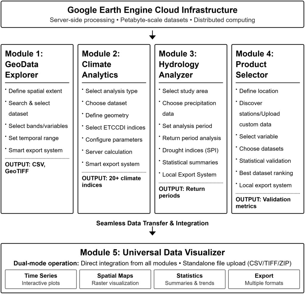
Five Powerful Modules, Zero Code Required
The platform comprises five integrated modules working seamlessly together:
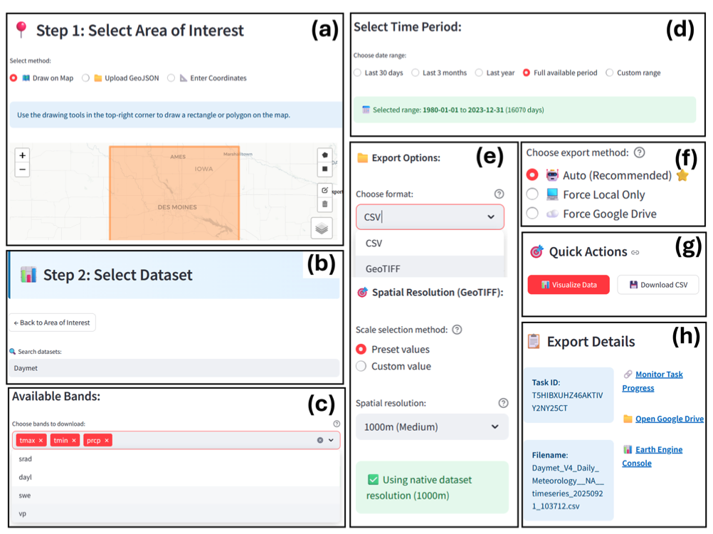
- GeoData Explorer – Provides intuitive access to 50+ climate datasets, with smart export capabilities handling everything from small regional studies to continental-scale analyses
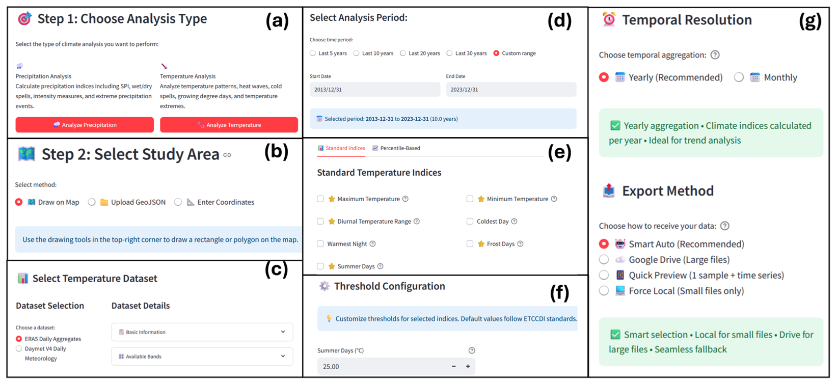
- Climate Analytics – Calculates over 20 internationally-recognized climate indices used in environmental research, from heat waves to drought events
- Hydrology Analyzer – Performs statistical precipitation analysis and return period calculations essential for infrastructure design and flood risk assessment
- Product Selector – Validates gridded climate datasets against ground weather stations, helping researchers choose region-specific most accurate data source
- Data Visualizer – Creates interactive visualizations and statistical summaries from all platform modules
The platform has already proven its educational value. When deployed in JSU’s Advanced Water Resources Engineering course, students successfully performed analyses previously considered beyond undergraduate capabilities—from watershed-specific probability distribution fitting to Mann-Kendall trend detection—all without writing a single line of code. “The feedback has been overwhelming,” Mr. Bhattarai shared. “Students who previously thought they needed years of programming training discovered they could conduct continental-scale climate analysis in their first semester.”
Open Access, Global Impact
True to its mission of democratizing environmental data analysis, the platform is completely free and open-source. It requires only a Google Earth Engine account (also free) and operates through any web browser—no software installation, no expensive licenses, no technical prerequisites. The platform is already being used by researchers and students across the globe analyzing a range of topics from urban heat island to drought assessments. “This represents a paradigm shift,” Dr. Pradhan emphasized. “We’re moving from a world where sophisticated environmental analysis requires months of programming training to one where domain expertise and critical thinking are the only prerequisites.”
The platform was developed through support from the U.S. Department of Defense, the ORISE Fellowship Program, and the Hydrological Impacts Computing, Outreach, and Resiliency Partnership (HICORPS) Project—a collaboration between ERDC, WOOLPERT-Taylor Engineering. Additional funding came from the Microsoft-Atlanta University Center Data Science Mini-Grant Program, which advances data science research at Historically Black Colleges and Universities.

Looking Forward
The research team is already working on expanding the platform’s capabilities. Future modules will address air quality monitoring, urban heat island assessment, and ecological habitat analysis. The open-source architecture invites community contributions, ensuring the platform evolves with emerging environmental challenges. “Every environmental science student deserves the opportunity to work with real data,” Mr. Bhattarai concluded. “Programming skills can come later—understanding climate patterns, analyzing drought risks, and thinking critically about environmental challenges shouldn’t wait.”
Access the Platform:
- Web Application: https://geeclimate.streamlit.app/
- Documentation: https://sauravbhattarai19.github.io/geoclimate-landing-page/
- Source Code:https://github.com/SauravBhattarai19/GeoClimate-Fetcher
Research Publication: Bhattarai, S., Pradhan, N.R., & Talchabhadel, R. (2025). GeoClimate intelligence platform: A web-based framework for environmental data analysis. Environmental Modelling & Software, 197, 106826.
Contact: For more information about the GeoClimate Intelligence Platform or collaboration opportunities, contact: saurav.bhattarai.1999@gmail.com
This research was conducted at Jackson State University’s Department of Civil and Environmental Engineering and the U.S. Army Engineer Research and Development Center’s Coastal and Hydraulics Laboratory.
GeoClimate Intelligence Platform: Democratizing Environmental Data Analysis Read More »